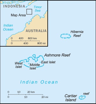
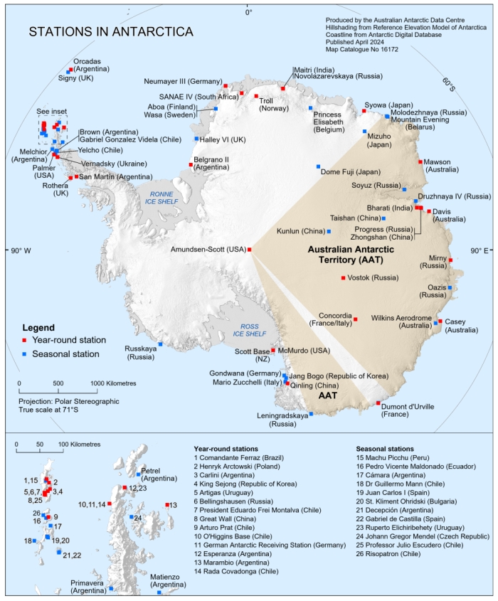
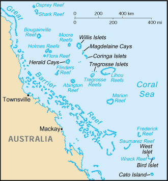
This record comprises the essentially uninhabited Australian external territories: the Ashmore and Cartier Islands and Heard and McDonald Islands in the Indian Ocean, the Coral Sea Islands Territory in the Pacific, and the Australian Antarctic Territory.
Ashmore and Cartier Islands
March 5, 1800: Captain Nash in the Cartier passes a "dry sand-bank," presumably the one that later comes to be called Cartier Island, before running aground the following day on another shoal. June 11, 1811: Captain Samuel Ashmore aboard the Hibernia discovers the Ashmore Islands, initially referred to as Ashmore Shoal. Mid-19th century: Phosphate (guano) deposits on Ashmore, found by American whalers, are mined. 1876: HMS Barracouta visits the islands. 1877-78: A Dutch attempt to assert sovereignty over Ashmore is withdrawn, apparently because of imminent British claims. December 1878: The United Kingdom takes formal possession of the Ashmore Islands, after there was some dispute over their ownership with the United States. Lt. William Tooker of the Airlie finds an American and two men in possession, but no objection is made to the hoisting of the British flag. May 16, 1909: Cartier Island is annexed when a landing is effected by HMS Fantome (Commander Fred Pasco), a flagstaff erected, and the British flag hoisted. July 23, 1931: By imperial order-in-council the islands are placed under the authority of the Commonwealth of Australia, effective on such date, after the passage of an acceptance act by the commonwealth parliament, as is to be fixed by governor-general's proclamation. Dec. 15, 1933: The Ashmore and Cartier Islands Acceptance Act 1933 is assented to. Proclamations are subsequently issued to make the transfer effective on May 10, 1934. July 19, 1938: The islands are annexed to, and deemed to form part of, the Northern Territory. 1950s: The islands are used as a bombing range and surveillance visits are made. 1950s-60s: Unmanned navigation lights, meteorological stations, and signs are constructed, and sporadic naval visits and aircraft surveillance continue. November 1974: A memorandum of understanding is signed with the Indonesian government permitting traditional fishermen to continue fishing in the territorial waters and to land on West Island to obtain supplies of fresh water. July 1, 1978: As the Northern Territory is given self-government, the Australian government assumes direct responsibility for the administration of the islands; this rests with a parliamentary secretary appointed by the minister for regional development, territories and local government. It is provided that a commonwealth law has application as if the islands were an "internal mainland territory," the only external territory treated this way. Periodic visits continue to be made to the islands by the Royal Australian Navy and the Royal Australian Air Force, and the Navy and the Australian Border Force undertake patrols of the islands and neighbouring waters to ensure their protection against illegal foreign fishing. August 1983: Ashmore Reef is declared a national nature reserve under the National Parks and Wildlife Conservation Act 1975. 1983-84: The oilfields of Jabiru and Challis are discovered in waters adjacent to the territory. The first petroleum production licenses are subsequently granted. Jabiru commences production in 1986 and Challis in 1989. 1985: An amendment to the Ashmore and Cartier Islands Acceptance Act provides for the extension of the laws of the Northern Territory to Ashmore and Cartier. 1985: An Australian presence begins to be maintained at Ashmore Reef during the March-November fishing season to monitor the activities of visiting Indonesian fishermen. 2000: Increasing numbers of asylum seekers attempt to land at Ashmore Reef, hoping to gain residency in Australia. The majority travelled from the Middle East via Indonesia. Consequently, late in the year a vessel with the capacity to transport up to 150 people is chartered to ferry unauthorized maritime arrivals to the Australian mainland. June 2000: Cartier Island Marine Reserve is established. September 2001: Ashmore and Cartier Islands are excised from Australia's migration zone, precluding unauthorized arrivals on Ashmore Reef from pursuing residency in the country. March 2004: A group of nine women and six men, believed to be seeking asylum in Australia, is discovered on Ashmore Reef. A government spokesperson reiterates the territory's exclusion from Australia's migration zone, stating that this will preclude the group from seeking any form of residency in the country. Further interceptions by the authorities of boats carrying migrants continue to occur periodically. April 2005: The Australian government invites petroleum exploration companies to bid for a number of leases which it has made available in an area covering some 920 sq km near the islands. December 2008: A vessel carrying suspected asylum seekers is apprehended by the Australian authorities in the vicinity of the Ashmore Islands; 35 passengers and five crew members are taken into custody, pending the processing of their claims. April 2009: In a major incident off Ashmore Reef, five people are killed when a boat carrying 47 Afghan asylum seekers, which was intercepted by the Australian navy, catches fire and sinks following an explosion. September 2010: Jabiru and Challis cease operating. November 2012: As part of a major expansion and reorganization of Australia's marine reserves, the Ashmore and Cartier reserves are renamed Ashmore Reef Commonwealth Marine Reserve and Cartier Island Commonwealth Marine Reserve, respectively, with both forming part of the Northwest Commonwealth Marine Reserves Network. June 7, 2013: The subsea well abandonment process is completed. July 2018: The Federal Circuit Court of Australia rules that the excision of Ashmore and Cartier Islands from Australia's migration zone, which entailed the declaration of Ashmore Reef as a port, was invalid. Government-proposed amendments to the relevant legislation, which seek to authorize the port declaration retrospectively, are approved by the House of Representatives in August and passed to the Senate for consideration. However, the bill lapses at the end of parliament on July 1, 2019. Aug. 19, 2018: At this time four petroleum production licenses are active in the territory, and 16 exploration permits and 9 retention leases are in force. Petroleum extraction activities offshore from the islands are administered by the Department of Primary Industry and Resources of the Northern Territory. Oct. 26, 2022: Indonesian tourism minister Sandiaga Uno claims Ashmore (Pulau Pasir in Indonesian) belongs to Indonesia, endorsing claims by indigenous leaders who have threatened to challenge Canberra in Australian court. Soon after Uno's statement, however, the Indonesian Foreign Ministry backtracks and confirms recognition of Australia's ownership.
Australian Antarctic Territory
1911-14: Australian explorer Douglas Mawson leads the Australasian Antarctic Expedition. Jan. 13, 1930: A new expedition by Sir Douglas Mawson having reached Antarctica on the Discovery, he proclaims British sovereignty for "the territory of Enderby Land, Kemp Land, Mac. Robertson Land [this area being so named after Australian philanthropist Sir Macpherson Robertson] together with off-lying Islands as located in our charts constituting a sector of the Antarctic regions lying between longitudes 47° E and 73° E and south of latitude 65° S." Feb. 18, 1931: Mawson's second proclamation is for "territory... extending continuously from Adélie Land, westwards to Mac. Robertson Land being that part of the Antarctic mainland and offlying islands... situate between meridia 138° and 60° E and south of latitude 64° as far as the South Pole." Feb. 7, 1933: A British order-in-council places the portion of Antarctica lying between 45° and 160° E excepting the French territory of Adélie Land (defined in 1938 as the area between 136° and 142° E) under the authority of Australia - an area of almost 6,000,000 sq km. June 13, 1933: Australian legislation accepting the territory, the Australian Antarctic Territory Acceptance Act 1933, is assented to. Aug. 24, 1936: The Australian Antarctic Territory is brought into existence by governor-general's proclamation. January 1938: Sir Hubert Wilkins raises the Australian flag on Antarctic islands and land previously claimed by Mawson. December 1946: As a result of lobbying by Sir Douglas Mawson, an interdepartmental committee recommends that the government commit to future Antarctic expeditions. August 1947: The Australian National Antarctic Research Expedition (ANARE) is proclaimed. March 1948: A base is established on the sub-Antarctic island of Macquarie, Tasmania. May 1948: The Antarctic Division of the Department of External Affairs (later the Australian Antarctic Division [AAD] in the Department of Environment and Energy) is established, to administer and provide support for ANARE, later the Australian Antarctic Program (AAP), covering the Australian Antarctic Territory as well as the Heard and McDonald Islands (see below) and Macquarie Island. Nov. 1, 1954: By the Australian Antarctic Territory Act 1954, the laws of the Australian Capital Territory are declared to be in force in the Australian Antarctic Territory, so far as they are applicable and not inconsistent with any ordinance made under the act. Feb. 13, 1954: A base, named Mawson (after Sir Douglas), is set up in Mac. Robertson Land, at 67°36´ S, 62°53´ E, for the conduct of meteorological and other research. Jan. 13, 1957: A second Antarctic base, named Davis (after the late Captain John King Davis, second-in-command of two of Mawson's expeditions), is established in the Vestfold Hills area, at 68°35´ S, 77°58´ E, some 600 km east of Mawson. Feb. 4, 1959: Australia assumes custody of the U.S. base at Wilkes on Budd Coast, at 66°15´ S, 110°32´ E. It was built by the United States (Jan. 16, 1957) as a temporary base for the International Geophysical Year, and it soon becomes evident that it will be buried by snowdrifts. Dec. 1, 1959: Australia is a founding signatory of the Antarctic Treaty, which enters into force on June 23, 1961. Richard Casey, as minister for external affairs, played a key role in its development. 1964: Australia commences work on a replacement station for Wilkes called "Repstat." Jan. 25, 1965: Davis is temporarily closed to concentrate resources on building Repstat. 1968: The responsibility for the administration of the Australian Antarctic Territory Act 1954 is transferred from the minister for external affairs to the minister for supply, and in 1972 to the minister for science. Feb. 15, 1969: Davis is reopened. Feb. 19, 1969: Repstat is officially opened. It is renamed Casey in honour of Governor-General Richard Casey, who was a staunch supporter of Australia's early Antarctic program. January 1976: The first women to visit an Australian Antarctic station in an official capacity work at Casey station for the summer season. December 1988: A new Casey station is officially opened. Late 1990s: Environmentalists express alarm at proposals to encourage tourism in the territory, which, they claim, could damage the area's sensitive ecology. November 2001: An international team of scientists commences Australia's largest-ever scientific expedition, to gather data on the influence of the Southern Ocean on the world's climate and the global carbon cycle. January 2002: Australia attempts to expel Japanese whaling ships from the 200-nautical-mile exclusive economic zone (EEZ) that it claims to be under the jurisdiction of the Australian Antarctic Territory. (The EEZ was included in the areas covered by the Australian Whale Sanctuary, which was established in 1999.) Mid-2005: The government is severely criticized for its failure to protect whales in its Antarctic territorial waters. Its reluctance to intercept Japanese whaling vessels for "diplomatic reasons" is blamed for the slaughter of more than 400 whales since 2000. December 2007: A permanent runway is opened at the Wilkins Aerodrome, located 75 km from Casey, and regular flights between the Tasmanian capital of Hobart and Antarctica become operational during the 2007/08 Antarctic summer season. January 2008: The Australian Federal Court rules that Japanese whaling activities within the Antarctic EEZ are illegal and issues an injunction against them. However, Japan, which does not recognize Australian claims to Antarctic land and sea territory, ignores the ruling. March 2014: The International Court of Justice, passing judgment on a case brought against Japan by Australia in May 2010, determines that Japan's whaling activities in the Antarctic contravene the provisions of the 1946 International Convention for the Regulation of Whaling. Japan temporarily suspends its activities, but resumes its whaling programme from the 2015/16 season. October 2014: The government publishes an Australian Antarctic Strategic Plan to guide engagement in the territory and advance Australia's influence in continental Antarctica over the next 20 years. The plan notes that budgetary restrictions imposed in recent years on the AAP diminished the capacity to conduct priority science activities. It is envisaged that the planned entry into service by 2020 of a new national ice-breaking vessel will improve year-round logistical, resupply, and research capabilities, and provide a platform for collaboration in scientific research with other countries engaged in Antarctica. Air transport services are also to be developed. Furthermore, deep field traverse capabilities are to be improved and the scientific stations are to be modernized. May 2016: Prime Minister Malcolm Turnbull announces that new funding totalling A$2,167 million will be invested over the next 10 years in support of the government's finalized Australian Antarctic Strategy and accompanying 20-year Action Plan. July 2016: The AAD Place Names Committee designates new names for 17 islands and 11 geographical features in the territory. Oct. 16, 2021: The new icebreaker, RSV (Research and Supply Vessel) Nuyina, constructed in Romania, arrives in Hobart.
Coral Sea Islands Territory
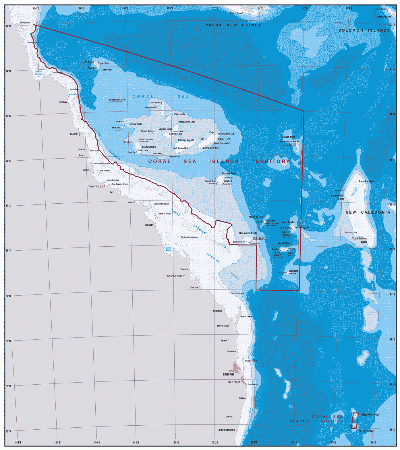
July 20, 1788: Lt. John Shortland discovers Middleton Reef, named in honour of Adm. Sir Charles Theodore Middleton. 19th century: Many ships are wrecked in the Coral Sea area as a result of constantly shifting sand cays and many of the reefs and islands are named after the ships which foundered. Aug. 17, 1803: The Cato and Porpoise, shortly after having discovered Cato Island, are wrecked on a reef, with one of Australia's most famous explorers, Captain Matthew Flinders, on board of the Porpoise. He survives and names it Wreck Reef. 1812: Frederick Reef is discovered by HMS Frederick. 1820: The ships Claudine and Marquis of Hastings report the existence of a reef to the south of Middleton Reef, presumably the one later known as Elizabeth Reef. 1821: Captain Tregrosse of the French ship Les Trois Frères discovers the Tregrosse Islets. 1844: The Osprey Shoal is discovered. 1854-60: HMS Herald visits many of the islands. Beacons are erected on Cato Island in 1854, Mellish Reef in 1859, and on Frederick Reef and Kenn Reef in 1860. Further scientific expeditions to the region follow, and many specimens of flora and fauna come to be housed in Australian herbariums and museums. 1860s-80s: The islands are briefly exploited for guano but subsequently abandoned. 1876: Malay Reef is discovered by the barque Malay. 1884: The Diamond Islets are discovered by HMS Diamond. Oct. 29, 1900: Letters patent purport to include within the boundaries of New South Wales all islands off the eastern coast of Australia that are not within the boundaries of Queensland, up to longitude 154° E. 1921: A meteorological station with a few staffers begins service on Willis Island. The remaining islands remain uninhabited. Feb. 6, 1936: A departmental minute to the minister for external affairs begins: "Until recently the question of the ownership of the small islands lying off the coast of Australia has not been of any great significance to the commonwealth." The islands and reefs "are virtually not annexed, or at least, might be subject to disputed ownership." The department says that the islands could be brought under Australian control "with little difficulty. As all but three of the islands can legitimately be claimed as British, all that is required to bring them under Australian control would be for action to be taken to have an order-in-council made under the Colonial Boundaries Act, to come into operation when the necessary legislation accepting the islands had been passed." Inclusion of all islands up to 158° E (the western limit of New Caledonia), plus Middleton Reef and Elizabeth Reef by specific reference, is envisaged. Increased Japanese fishing activities, reawakened French and German territorial interests, developing transoceanic air services, and Australia's growing naval effectiveness give the islands a distinct potential value; no actions are taken, however, until World War II breaks out in 1939, diverting attention to other matters, and afterwards the issue is again taken up with no great urgency. 1967: Extensive surveying begins to be undertaken by the Australian Department of National Development. Aug. 16, 1968: The U.K. government advises that it does not "claim any right or interest in [the islands] which is inconsistent with the exercise over them by the Australian government of effective government, administration, and control. The United Kingdom government accordingly recognize that Her Majesty's sovereignty over the islands, and effective government, administration, and control over them, is exercised by the Australian government." Sept. 30, 1969: The Coral Sea Islands Territory - though extending over a sea area of about 780,000 sq km (the eastern boundary being at 157°10´ E), totalling only a few sq km of land area - is established under the Coral Sea Islands Act. The Department of the Arts, Sport, the Environment, Tourism and Territories in Canberra is responsible for the administration. Oct. 19, 1973: An ordinance specifies that the laws of the Australian Capital Territory, so far as applicable, shall be applied to the Coral Sea Islands Territory. Aug. 16, 1982: The Lihou Reef and Coringa-Herald national nature reserves are declared to provide protection for a wide variety of terrestrial and marine wildlife, including rare species of birds and sea turtles. June 25, 1984: The Statute Law (Miscellaneous Provisions) Act (No. 1) 1984 is assented to, by which the boundaries of the territory are amended, the eastern boundary being set at 156°06´ E. Dec. 11, 1987: Elizabeth and Middleton Reefs are declared a Marine National Nature Reserve under the National Parks and Wildlife Conservation Act.
The new borders of the Coral Sea Islands Territory, including Elizabeth and Middleton Reefs (bottom right).
July 7, 1997: An omnibus act is assented to, as part of which the Coral Sea Islands Act is amended to include Elizabeth and Middleton Reefs. Nov. 8 and 17, 2012: Two new marine reserves are created: the 110,139-sq-km Lord Howe Commonwealth Marine Reserve - which includes the former Lord Howe Island Marine Park (Commonwealth Waters) and the former Middleton and Elizabeth Reefs Marine National Nature Reserve - and the Coral Sea Commonwealth Marine Reserve, covering 989,842 sq km and encompassing the former Coral Sea Conservation Zone and Lihou Reef and Coringa-Herald national nature reserves. The new reserves formally protect the area from overfishing, and from petroleum and gas exploration. Oct. 9, 2017: The Coral Sea Commonwealth Marine Reserve is renamed Coral Sea Marine Park.
Heard and McDonald Islands
Nov. 25, 1853: The first confirmed sighting of Heard Island is made by Captain John Heard on the U.S. merchant vessel Oriental. Earlier sightings of land in the area in the 1830s (notably the claim that the British sealer Peter Kemp, master of the brig Magnet, sighted Heard in 1833) are considered doubtful. Jan. 4, 1854: The small, rocky McDonald Islands (some 40 km west of Heard Island) are discovered by Captain William McDonald of the British ship Samarang. 1854/55: The killing of elephant seals at Heard Island and rendering of their oil commences, oil production peaking in 1857/58. Following the near destruction of the seals, oil production continues until 1877. The poor weather conditions and lack of sheltered harbours along the coast mean that many vessels run aground at the island. 1874: The first recorded scientific visit to Heard Island is by the Challenger, when a brief landing is made at Atlas Cove and a few scientific samples are collected. Poor weather limits the visit to 3 hours. Later the same year, the Arcona brings a German expedition to the island, looking for suitable sites for observing a transit of Venus. The poor weather likely discourages their interest in the island. Feb. 3, 1902: The German Antarctic Expedition's ship Gauss lands a small team at Atlas Cove for a brief visit to make observations and collect samples. 1908: The British government agrees to consider a Norwegian application to lease the islands. 1910: Britain grants an option (which is not exercised) to a private individual to occupy the islands for three years; in the same year, a British ship visits, a beacon is erected, and the Union Jack is hoisted. 1926: A British company in South Africa is given a 10-year lease over the islands, the lease permitting the British flag to be displayed in proof of occupation. The company ceases to exercise its rights in 1930, and the lease is terminated in 1934. January 1928: An 8-day visit to the Atlas Cove region is made by two French geologists.
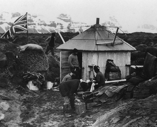
British flag flown at Atlas Cove, Heard Island, November 1929.
Nov. 26-Dec. 3, 1929: The British, Australian, New Zealand Antarctic Research Expedition (BANZARE), led by Sir Douglas Mawson, visits Heard Island. A British flag is flown at an old Norwegian sealer's hut at Atlas Cove, though no formal claim is made as British sovereignty is already considered evident. As with previous visits, poor weather reduces the duration of the visit and limits the scientific investigations by the field party. Dec. 11, 1947: Australia establishes a research station at the northwestern end of Heard Island, at Atlas Cove. The station was originally planned for Spit Bay at the eastern end of the island, but poor weather prevented landing operations there. On December 26 the chief executive officer of the Australian National Antarctic Research Expedition (ANARE), Stuart Campbell, reads out a declaration of Australia's intention to occupy and administer the islands. The Australian cabinet is informed that a British communication a few days earlier "formally confirmed the willingness of the United Kingdom government to transfer to His Majesty's government in the Commonwealth of Australia their rights in Heard and McDonald Islands. In order to avoid undesirable publicity or criticism in overseas countries, possibly precipitating other claims to the islands, it has, so far, been considered inadvisable for the Australian government to make any public announcement regarding its negotiations with the United Kingdom government." Dec. 19, 1950: Transfer of sovereignty of the islands as from Dec. 26, 1947, is confirmed by an exchange of notes between the British and Australian governments. April 24, 1953: The laws of the Australian Capital Territory are declared to be in force in the Territory of Heard Island and McDonald Islands by the Heard and McDonald Islands Act 1953. March 9, 1955: The station is closed down following the establishment of Mawson on the Antarctic continent in 1954 (see Australian Antarctic Territory, above). During its existence, 91 expeditioners wintered on Heard Island. January-March 1963: A number of Australian scientists and a small climbing party are landed on the island. Poor weather prevents the climbers from reaching the summit of Big Ben, the 2,750-m high glacier-covered active volcano that dominates the island (higher than Mount Kosciuszko [2,228 m], mainland Australia's highest peak). 1964-65: The Southern Indian Ocean Expedition, the first private expedition to Heard Island, visits with the aim of climbing Big Ben. The climbers are landed at Capsize Beach - so named as the surf overturned their boats on landing - and successfully reach the summit on Jan. 25, 1965. 1968: The responsibility for the administration of the Heard and McDonald Islands Act 1953 is transferred from the minister for external affairs to the minister for supply, and in 1972 to the minister for science. March 1969-April 1970: The ANARE station at Atlas Cove on Heard Island is occupied by American scientists involved in the U.S. Coast and Geodetic Survey. The scientists' objective is to photograph a satellite in orbit. These photographs are to be used in triangulation calculations to determine the shape and size of the Earth, and to determine the relative locations of the photographic stations. Unfortunately, poor weather limits the number of photographic opportunities. Early 1971: A joint French-Australian expedition visits Heard Island for 6 weeks. During this expedition, the first landing is made on McDonald Island (January 27). A helicopter lands two scientists for 45 minutes for a brief inspection. Early 1980: A National Mapping expedition visits Heard Island for little more than 2 weeks. During this visit, the second landing is made on McDonald Island, this time by amphibious vehicle. A small team is present on the island for 5 days conducting the first scientific surveys of the island. Early 1983: A second mountaineering expedition visits Heard Island and is successful in its attempt to ascend Big Ben, reaching the summit on two occasions. Another expedition is present at that same time, consisting mainly of ham-radio enthusiasts, but including also a small mountaineering team, which makes an unsuccessful attempt to climb Big Ben. Summers 1985-86 to 1987-88: Three extended visits are made to Heard Island, with the 1987-88 expedition present on the island for 5 months. 1990: A short month-long midwinter visit is made by a team of four at Spit Bay. January 1991: An international team of scientists travels to Heard Island to conduct research involving the transmission of sound waves beneath the surface of the ocean, in order to monitor any evidence of the greenhouse effect (melting of polar ice and the rise in sea level as a consequence of pollution). The pulses of sound, which travel at a speed largely influenced by temperature, are to be received at various places around the world, with international cooperation. Heard Island is chosen for the experiment because of its unique location, from which direct paths to the five principal oceans extend. January 1992-March 1993: Five expeditioners winter on Heard Island. 1992, 1997, 2002: Tourists land on Heard Island, in each case from the Russian ice-breaking vessel Kapitan Khlebnikov at Spit Bay and/or Atlas Cove. January 1997: Another ham-radio expedition spends less than three weeks at Atlas Cove. They establish their own camp and make more than 80,000 contacts with other ham-radio operators around the world. Late 1997: The Heard and McDonald Islands are accorded World Heritage status by the United Nations Educational, Scientific and Cultural Organization (UNESCO) in recognition of their outstanding universal significance as a natural landmark. 1999: Concern is expressed that stocks of the Patagonian toothfish in the waters around the islands are becoming depleted as a result of over-exploitation, mainly by illegal operators. (The popularity of the fish in Japan and the U.S., where it is known as Chilean sea bass, increases significantly during the early 21st century.) Summer 1999-2000: The third ascent of Big Ben is made by a small team of four climbers from the Australian army. Summer 2000-01: A major expedition to Heard Island involves 55 research and support personnel working from the main camp at Atlas Cove, a secondary camp at Spit Bay, and a small camp at Brown Glacier on the east coast. A team of glaciologists finds that since 1947 Brown Glacier has lost 38% of its total volume. October 2002: The Australian government declares the establishment of the Heard Island and McDonald Islands Marine Reserve, strengthening existing conservation measures and imposing an official ban on all fishing and petroleum and mineral exploitation. Among the many species of plant, bird, and mammal to be protected by the reserve are the southern elephant seal, the sub-Antarctic fur seal, and two species of albatross. The islands are also an important habitat for several species of penguins. Limited scientific research and environmental monitoring are to be allowed. August 2003: A Uruguayan fishing vessel is seized, following a 20-day pursuit over 7,400 km by Australian, South African, and British patrol boats. The trawler was fishing illegally in waters near the islands and has a full cargo of Patagonian toothfish worth some U.S.$1.5 million. In December the Australian government announces that it is to send an ice-breaking patrol vessel with deck-mounted machine guns to police the waters around the islands with the aim of deterring illegal fishing activity, much of which is believed to involve international criminal organizations. Summer 2003-04: The Australian Antarctic Division (AAD) conducts a multi-disciplinary scientific expedition to Heard Island. The party of 28 scientists and support staff spends two months on the island undertaking a range of programs including animal, bird, and terrestrial biology and glaciology. August 2005-August 2012: The first Marine Reserve Management Plan, covering this period, introduces measures further to restrict human activity on the islands, in an attempt to protect their unique flora and fauna from damage and from introduced organisms. March 2012: Following an intensification of efforts to eliminate illegal fishing and the implementation of measures to conserve stocks, the Marine Stewardship Council certifies Heard and McDonald Islands fishery as being sustainable and well managed. March 2014: The area of the Marine Reserve is expanded from 65,000 to 71,200 sq km. May 2014: A prohibition on entry, without authorization, to the territory takes effect, implemented by the director of the AAD following a review of the first plan. October 2014: A second Marine Reserve Management Plan, covering the period 2014-24, is approved by the Australian government and focuses, inter alia, on biosecurity, the impact of climate change, and waste management. The islands remain the only unmodified example of a sub-Antarctic island ecosystem in the world. March 2016: Another ham-radio expedition visits Heard Island. October 2024: Australia announces a 310,000-sq-km expansion of the Heard Island and McDonald Islands Marine Reserve, quadrupling its size. It comes into effect Jan. 24, 2025. April 2, 2025: The islands make a rare appearance in world news when U.S. president Donald Trump in his global tariffing spree includes them on his list with a 10% tariff, prompting much ridicule that he is putting a tariff on penguins. Trade statistics do show the U.S. imported a small amount of goods from the territory in past years, almost entirely classified as machinery and electrical equipment. However, several shipping records show that goods from Europe were erroneously marked as coming from the territory. October 2025: The AAD undertakes the first research visit to the islands in more than 20 years, using the icebreaker RSV Nuyina, spending 10 days at Heard Island. A second visit in December 2025-January 2026 involves a 25-day program. Researchers find the islands littered with seal carcasses. In June 2026 Australian scientists say that bird flu killed more than 13,000 elephant seal pups, the virus having likely been introduced in August 2025 by infected wildlife that travelled from the Crozet Islands, about 1,500 km to the northwest.