Rulers: United Kingdom
British Antarctic Territory
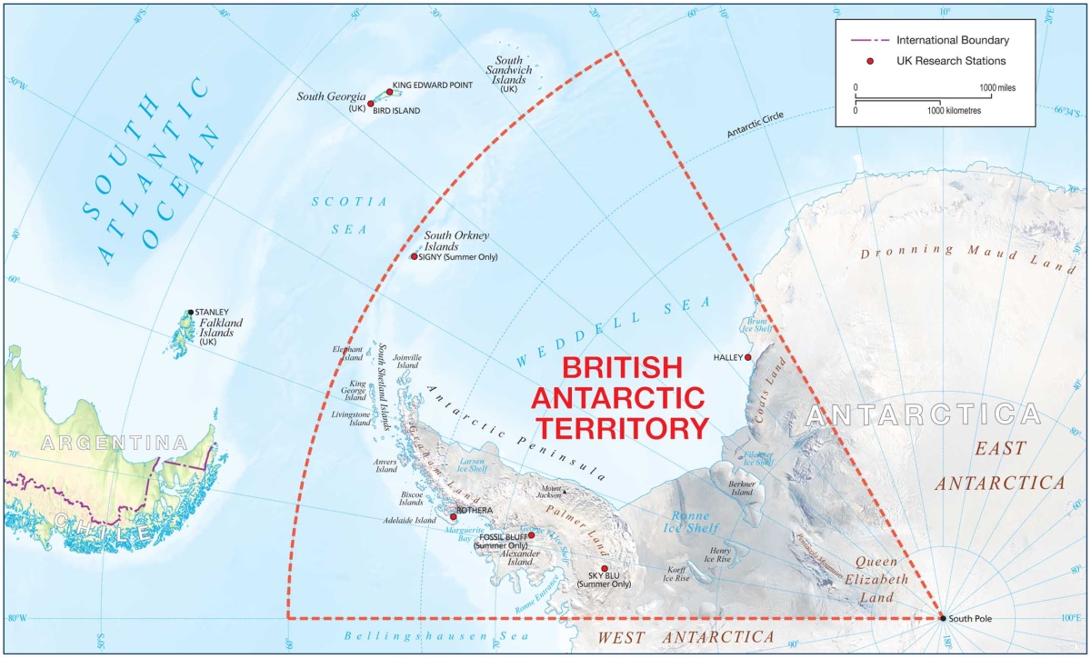 |
The British Antarctic Territory comprises the sector of Antarctica from 20° to 80° W, including the Antarctic Peninsula and the South Orkney and South Shetland Islands.
Feb. 19, 1819: The South Shetland Islands are discovered by the British mariner William Smith in his ship Williams.
Jan. 30, 1820: Smith in the Williams discovers the northwestern coast of the Antarctic Peninsula, coming only days after the continental Antarctic landmass was first sighted by a Russian expedition.
November 1820: U.S. sealer Nathaniel Palmer explores the Antarctic Peninsula southward of Deception Island in the Hero. The peninsula comes to be named Palmer Peninsula after him.
Dec. 6, 1821: The South Orkney Islands are discovered by George Powell on the Dove.
1828-29: Captain Henry Foster of the Royal Navy explores and claims parts of the Antarctic mainland.
Feb. 21, 1832: The Antarctic Peninsula is claimed for Britain by the explorer John Biscoe.
1841-43: Sir James Clark Ross circumnavigates the continent. On Jan. 6, 1843, he lands on the eastern shore of Palmer Peninsula, claiming James Ross Island and all "contiguous lands" for the British crown.
1898-1900: The British Antarctic Expedition is led by Carsten Borchgrevink.
1901-04: A larger British National Antarctic Expedition is led by Captain Robert Falcon Scott.
1908: The U.K. is the first to make a formal territorial claim on the Antarctic continent, via the Falkland Islands Dependencies Letters Patent.
January 1944: Operation Tabarin, a 14-man Admiralty expedition led by Lt. James Marr and Maj. Andrew Taylor, departs from the Falklands. The mission has multiple objectives including frustrating any enemy activity in the region (during World War II), strengthening British territorial claims, and collecting scientific data. Bases are initially established on Deception Island, a natural harbour in the South Shetland Islands, and at Port Lockroy just off the Antarctic Peninsula. In 1945 these stations are transformed into the Falkland Islands Dependencies Survey (FIDS).
March 18, 1947: The Signy Island base is established in the South Orkney Islands.
December 1947: After an Argentinian naval expedition landed on the South Shetlands and South Orkneys and established bases in British Antarctica, the British government proposes the submission of its claim to sovereignty over the dependencies (which also involves Chile) to the International Court of Justice; this is rejected by both Argentina and Chile, which express the conviction of their "indisputable rights" to the "South American Antarctic."
Feb. 1, 1952: Argentine personnel open fire with a machine gun over an unarmed British scientific party arriving at the former (1945-49) FIDS station at Hope Bay, where Argentina set up the Esperanza station in December 1951. The British base is nevertheless reopened on February 4, and another Argentine station built in 1953.
Jan. 15, 1956: The Halley Bay research station is established on Brunt Ice Shelf. As any object on the shelf quickly gets buried by snow accumulation, new stations are built in the same area: Halley Bay II (1967), Halley Bay III (1973; in 1977 renamed Halley III), Halley IV (1983), Halley V (1992), Halley VI (officially opened Feb. 5, 2013).
Dec. 1, 1959: The U.K. is an original signatory of the Antarctic Treaty (effective June 23, 1961). The treaty puts all sovereignty claims in abeyance.
Feb. 3, 1961: The Adelaide Island research station is established (known as Adelaide from July 1962).
Feb. 20, 1961: The Fossil Bluff station is established on Alexander Island.
Jan. 1, 1962: The FIDS is renamed the British Antarctic Survey (BAS).
March 3, 1962: The British Antarctic Territory is formed, no longer a dependency of the Falkland Islands, but continuing to be administered from the Falkland Islands. The Falkland Islands Dependencies are reduced to South Georgia and the South Sandwich Islands, north of the Antarctic Treaty perimeter (60° S).
Feb. 1, 1963: The first British Antarctic Territory stamps are issued.
March 1964: A U.S.-British Commonwealth agreement gives the name "Antarctic Peninsula" to the area previously known as Palmer Peninsula to the U.S. and as Graham Land to the British. Under the agreement, which ends decades of dispute, the northern part of the peninsula is named Graham Land, the southern part Palmer Land.
April 1, 1967: Responsibility for the BAS is transferred to the secretary of state for education and science.
Oct. 25, 1975: The Rothera research station is established.
March 1, 1977: The Adelaide station is closed.
August 1977: The Signy Island base is renamed Signy.
July 1, 1989: Responsibility passes from the Falkland Islands to the newly created office of commissioner of the British Antarctic Territory (in the Foreign and Commonwealth Office in London).
1991: The RRS (Royal Research Ship) James Clark Ross becomes the first BAS vessel purpose-built as a science platform. She replaces RRS John Biscoe.
May 1991: It is reported that the U.K. has invested £19,000,000 to build an airstrip at the Rothera station. The Antarctic Committee of Wildlife Link, an environmental umbrella organization, expresses fears that the use of the airstrip will encourage tourism and precipitate mineral exploitation.
February 1995: The Sky-Blu research station, in southern Palmer Land, is established.
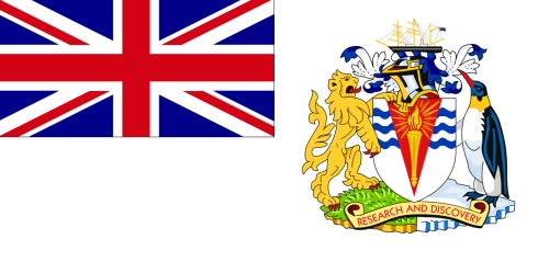 |
April 21, 1998: A flag for the territory is adopted. It has a white field bearing the union flag of the U.K. in the canton and, in the centre of the fly half of the flag, the territory's coat of arms, which consists of a white shield with three wavy blue horizontal lines at the top overlapped by a red triangle, apex downwards, bearing a brown and yellow torch with red-bordered yellow flames framed by golden rays, the shield supported by a golden lion and a black and white penguin with a yellow throat, both supporters surmounted by a scroll of yellow with a red reverse and the red inscription "RESEARCH AND DISCOVERY"; above the shield, a helmet supporting a torse is depicted below a sailing ship flying the British Blue Ensign at the gaff.
1999: The RRS Ernest Shackleton enters service, primarily providing logistical support, replacing RRS Bransfield.
Sept. 28, 2001: A fire breaks out at the Rothera base which totally destroys the Bonner Laboratory (opened in January 1997). In December the U.K. announces that it will construct a new laboratory.
Dec. 18, 2012: The U.K. government announces that about one-third of the territory, which was previously unnamed, has been named Queen Elizabeth Land to mark Queen Elizabeth II's 60 years as British monarch. Argentina "strongly rejects" Britain's right to rename the area.
Jan. 27, 2013: A Dutch research facility, the Dirck Gerritsz Laboratory, opens as part of the Rothera research base.
April 25, 2014: The British government announces that a new research vessel, with enhanced ice-breaking capabilities, is to be commissioned; the vessel, which is to replace the RRS Ernest Shackleton and the RRS James Clark Ross, will be operated by the BAS on behalf of the Natural Environment Research Council. The latter conducts an online poll in March-May 2016, asking the public to help name the ship. The most popular name is Boaty McBoatface (33%). This being disregarded, in May it is announced that the ship will be called the RRS Sir David Attenborough (though the name Boaty McBoatface will be used for a remote-controlled submersible). Construction begins in October. It is completed in December 2020.
December 2016: The relocation, in stages, of the Halley VI research station, comprising eight modular buildings, commences. The relocation of the station some 23 km inland is necessitated by potential access problems caused by a growing chasm and cracks in the ice shelf. The move is completed in March 2017. Owing to further breaks in the ice shelf, all staff leave Halley VI in the following winters.
Jan. 22, 2023: An iceberg almost the size of Greater London breaks off the Brunt Ice Shelf, site of the Halley VI station.